I thought I'd share some of the maps. It's fun playing "what if" in terms of landscape geology. Plus, it gives me a chance to exercise my drawing skills:
 (click to embiggen)
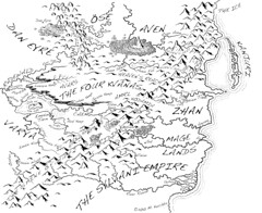
Here's the "world" map - the biggest challenge was keeping the countries and cities in the same location relative to each other (determined by the author), while portraying the geomorphic features in a reasonably accurate fashion. That involved placing the rivers in patterns that showed proper downstream morphologies and drainage patterns, coastal features that reflected some river/shoreline processes, and adding a different kind of "mountain" range to the northwestern area of the map. I thought placing some Karst towers would be something different, compared to the mountains that are usually drawn.
 (click to embiggen)
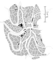
The city map (in progress), has to balance a sense of urban development history (old neighborhoods, new ones springing up and gentrified areas) superimposed onto a landscape that had some plot-relevant hills. I placed some neighborhoods on river terraces to to justify the higher hill tops (left behind as the river eroded downward).
No comments:
Post a Comment