- More horizontal pixels for the main body text
- More photographs
- MOAR Cats
- More squid
- More snails
- More rocks
- Goat Pants?
- More frac sand posts
- More High Speed video
- Unscented deodorant
- Something wicked
- More invented words
- Enhanced links and keywords
- More plants
- Something about skeletons
- Something else about skeletons
- Something about dinosaurs that isn't about skeletons
- Additional information about regional geology
- A detailed review of the claim made by the pretender to the throne
- I should probably bake something
- At this point, you should probably look for someone to kiss
- Cat Vests?
- R- versus K-selection in the various Quendi races in The Lord of the Rings
- Tempo and Mode of evolution
- I will try to type without using vowels or verbs at least once a month
- If you are lucky, I will post more interesting tidbits about bookshelves
- Hidey-hidey hidey hidey-hi
- Scoodle-ee-boo, Scoodle-ee-boo, Scoodle-ee-boodle-ee-boodle-ee-boo
- No showtunes unless they be of a geological theme (or I'm feeling punchy)
- Geology sketchbook color by number
- I really want to go to Scotland
- If it ain't scottish it's crap
- Only 40 minutes left...
- Ringing in the New Year by Wringing out the Old
- Something related to dirt should be a fun topic or three
- Get ready, here it comes...
- HAPPY NEW YEAR!!!
Saturday, December 31, 2011
New Year's Resolutions
I hope to keep up some of the momentum gained from this year. Here are some of my bloggy resolutions for the new year:
A Squidlet?
I'm going to be an uncle in a few months. My sister's first kid is due on March 1st and true to form, she didn't want to have a traditional "Shower," so we got together for a non-shower baby party for her and her husband (who is also a college professor, BTW). I drew up a card to congratulate them:

That's the cutest cephalopod I've ever drawn if I do say so myself...

That's the cutest cephalopod I've ever drawn if I do say so myself...
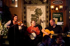
Hand a guy a camera...
So I do this thing where by day I'm a geology professor, but at night and on weekends I take pictures. Last night we trekked over to Stillwater, MN where Paul and Lorraine were playing. I brought my camera and managed to get some okay shots of them playing (I usually haul some photo gear around because, you know, pictures happen). Kind of wish I could have gotten the folks at the front table out of the shot, but I needed the faster wide lens to make use of the available light (30mm f1.4 @ ISO 3200 for those of you who want to know)

I'm ruminating on a end-of-year post, so you might get more from me before the year's out.
I'm ruminating on a end-of-year post, so you might get more from me before the year's out.
Thursday, December 29, 2011
Capillary Rise Experiment crosses 1000 hr point
My ongoing capillary rise experiments have crossed the 1000 hour mark! And the data still looks pretty.


A review and call reversal from the line judge
An astute reader noticed that my geology photo from a few weeks ago was probably misidentified. I was looking at a top-down satellite image of the Big Island of Hawai'i and trying to extrapolate which peaks I was looking at in this picture:

I had originally identified them as Mauna Loa, Mauna Kea, and Kohala. However, one reader questioned my original ID. And after looking more carefully (and not early in the morning before I had coffee), I had to agree with MacLaren that I had Mauna Kea and Mauna Loa switched. Then the reader suggested I was actually seeing Hualalai and not Kohala. I looked at the geometry of the image and from the satellite photo I wasn't 100% sure of that. So I went to the ultimate arbiter of what one can see from a particular spot: Google Earth. And sure enough, MacLaren was spot on:

I guess the moral of the story is this: double check your geographic reference points - using Google Earth can be very helpful - and welcome suggestions from readers. I probably wouldn't have noticed my error until much later without MacLaren's suggestions. Thanks :)
Wednesday, December 28, 2011
Asplody Sand
While I've always known that getting good video footage or great photographs often requires some setup, high speed video demands another level of pre-planning. That's one of the reasons for shooting so many test clips early on - the more I know what is going to be needed for capturing high speed video, the quicker it will go in the future. So here's a bunch of "meteorites" impacting some alien planetary surface.
I think it's time to get these impactors moving at higher speeds.
I think it's time to get these impactors moving at higher speeds.
Saturday, December 24, 2011
Happy Holidays and all that
Based on my readership stats, I suspect many of my readers are heading off to, or celebrating Christmas/Yuletide traditions with their families. I have one last high speed video to share with you before my wife and I head off to meet with one of several holiday gatherings over the next week - blogging will probably be light for me then.
Friday, December 23, 2011
Bonus Thurs-Demo: The One Dropping a Slinky
Have you ever dropped a slinky? If you've never looked closely at a free falling slinky, well you've come to the right place. But dropping a stretched slinky doesn't do what you might think. Take a look at the high speed:
Rhett Allain went so far as to build a computer model of a falling slinky to illustrate why the bottom of the slinky doesn't move until the top catches up. (Down?)
Rhett Allain went so far as to build a computer model of a falling slinky to illustrate why the bottom of the slinky doesn't move until the top catches up. (Down?)
Thursday, December 22, 2011
Thurs-Demo: The one in Slow Motion
New technology is fascinating. I've spent the day setting up a new camera that just arrived. Here's a little demonstration:
Tuesday, December 20, 2011
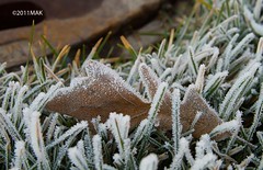
Frost
While many places to the south are getting a lot of ice and snow, some hoarfrost depositing (directly from vapor to a solid) on the lawn on campus was about the only white stuff on the ground around here.
Grading Amusement
I'm grading my Soil Mechanics finals right now. I have a questions about Apatosaurus. Being a large dinosaur with a weight of about 28 tons, if we assume each of its four feet was 3 feet in diameter, how much stress does this dinosaur apply to the soil beneath its feet?
Students should be able to determine the total area that the dinosaur is in contact with the ground (4 x (1.52 x 3.14159) = or about 28 square feet. Their answers should be about 1 tsf (28t/28sf) - many of the students get this, but some students just skip the question. Why? I think because there's math involved, which makes me kind of sad. One student didn't skip the question, but instead wrote:
Thank you student. You don't get the points, but you get kudos for making me smile.
Students should be able to determine the total area that the dinosaur is in contact with the ground (4 x (1.52 x 3.14159) = or about 28 square feet. Their answers should be about 1 tsf (28t/28sf) - many of the students get this, but some students just skip the question. Why? I think because there's math involved, which makes me kind of sad. One student didn't skip the question, but instead wrote:
a lot, dinosaurs are huge
Thank you student. You don't get the points, but you get kudos for making me smile.
Monday, December 19, 2011
mnemonic for an XKCD comic
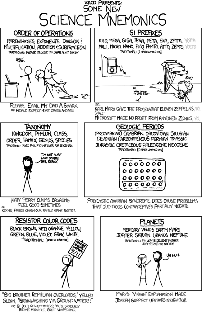
So, according to the comic, the creator of the always entertaining XKCD comic never learned a good mnemonic for the geologic periods. That's too bad. Perhaps we can help him. Here are the ones I use:
Can Oscar See Down My Pants Pockets? Two Jasons Can Pick Noses.
Cambrian
Ordovician
Silurian
Devonian
Mississippian
Pennsylvanian
Permian
Triassic
Jurassic
Cretaceous
Paleogene
Neogene
And for those of you who take the time to split of the Paleogene/Neogene (nee Tertiary) into epochs: Say it as one word (PEOMPPH)
Pronounced: "Pee-Ompff"
Paleocene
Eocene
Oligocene!
Miocene
Pliocene
Pleistocene
Holocene
And to keep the "P" epochs organized, "paleo" means old, so that one goes first, while the Pleistocene is often used synonymously with "Ice Age" and that was just before the Holocene. Of course, most of us who have been to a GSA meeting also have a handy pocket timescale (or something a little more substantial):

So, what's yours trick to remembering geologic time units? Perhaps we can send XKCD some suggestions...
Monday Geophoto?
It looks like Evelyn is going strong with the geophotos and now has a regular theme for mondays. Lockwood and several others went the extra mile and posted additional photos during the weekend, too (via Twitter).
My monday entry is something a little different. Less of a geology photo and more of a photograph taken by a geologist. While the lamp post and the White Witch are standing on an intermediate terrace and Mr Tumnus is perched on a riser adjacent to the floodplain of a small tributary stream, this image is more about what I hope to do more of during my vacation. There are a lot more students on campus than I have seen in the last few weeks and there's the coppery-tinged smell of last minute panic hanging in the air. It must be finals week. Therefore, I will have some unobstructed time to do some paper revisions (yeah, the #sciwrite didn't get me very far...) plus some fun stuff.
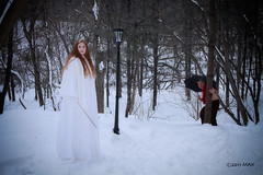
Like this set of pictures I made of my friends because there was a Narnia lamp post available and Kelly McCullough had some goat pants.
My monday entry is something a little different. Less of a geology photo and more of a photograph taken by a geologist. While the lamp post and the White Witch are standing on an intermediate terrace and Mr Tumnus is perched on a riser adjacent to the floodplain of a small tributary stream, this image is more about what I hope to do more of during my vacation. There are a lot more students on campus than I have seen in the last few weeks and there's the coppery-tinged smell of last minute panic hanging in the air. It must be finals week. Therefore, I will have some unobstructed time to do some paper revisions (yeah, the #sciwrite didn't get me very far...) plus some fun stuff.
Like this set of pictures I made of my friends because there was a Narnia lamp post available and Kelly McCullough had some goat pants.
Friday, December 16, 2011
Painting with Light
Following up with the quick video from yesterday, I decided to try and draw with the laser pointer. The fading glow of the BBs would give me a guide so that I could draw a second picture a little different from the first. And so on... stacking a whole bunch of still pictures together, I made a short stop-animation movie as a result. Nothing terribly complex yet, I'm still getting the hang of the process.
Here's the setup.

And here are a couple of finished animations. Incidentally, this is kind of like how old vacuum tube television sets worked. An electron "gun" at the back of the set would hit a bunch of phosphorescent spots on a glass screen and light them up. They'd emit red, green, or blue light and a whole bunch of dots together would make an image. A whole bunch of images played at about 30 frames per second would create the illusion of movement.
Friday Field Foto (Geopics, Day 5)

Today's picture is from south-central Utah near the town of Sevier. I'm not sure what the name of the conglomerate the students are running around on, but it's approximately correlative to the Indianola or Price River formations (Late Cretaceous). This is stuff that was tumbling down the mountains being uplifted during the Sevier orogeny.
I was shooting pictures with a tilt-shift lens, so I made everything look a little funky on purpose. But you can also see the canon-ball-sized boulders that make up much of this sedimentary rock.
Thursday, December 15, 2011
Happy Holidays!
Things are winding down and many of us are getting set to shuffle off to grade finals, meet with family and recuperate from the year. One of my resolutions for 2012 is to redo the "reactor" demo so that it has a little bit more "oomph."
But, I still hope everyone has a wonderful holiday full of cheer and happiness. And only a little fission.
But, I still hope everyone has a wonderful holiday full of cheer and happiness. And only a little fission.

Thurs-Demo: The One that Rises
Whew! Another semester is almost finished. Just a couple of final exams and #gradingjail to go now. Here's a demo that isn't exactly quick - to really see the results you need to let the thing go for about 1000 hours...
The height above some free water surface (such as the water table) that surface tension can "pull" a column of water is proportional to the size of the pores between the soil grains. Like "capillary tubing" where the narrower the diameter of the tube, the higher water can move above the free water surface, the smaller the space between granular particles, the higher the capillary rise. This demo works well in medium and fine sands, although the highest capillary rise (perhaps up to a few meters) occurs in silts. There is minimal capillary rise between tiny clay particles due to their shape - they pack together closely enough to inhibit water movement.

The graph above shows the results from several iterations of the experiment. The colored dots represent the experiment that is ongoing (and shown in the video). What's really cool is that by using video tracking, I can refine my time measurements down to the first few seconds of the experiment. Expanded to 1000 hours, that gives me a data set that covers over seven orders of magnitude. I'm struck by how consistent this movement is between experimental runs and different grain sizes (the higher the mesh number, the smaller the particles).
Geology Photos, Day 4 - Unintentionally Ironic

Wednesday, December 14, 2011
Fun with "Blue" Lasers!
Following Rhett Alain's example, I shined a blue laser through some household items to see what would happen.
White wine - interesting, but not amazing.

Window cleaner - neat, but still blue.

GOO GONE. Now we're talking!

White wine - interesting, but not amazing.

Window cleaner - neat, but still blue.

GOO GONE. Now we're talking!

Geology Photos, Day 3 - Quartz Arenite
Evelyn's got a really cool picture of a coral "boulder." But when they're that sized, do they really qualify as boulders? And what if it's cemented to the material beneath it? Is it just a pinnacle? Although since we're all travelers on a little blue pebble, perhaps one needs to acknowledge the context and worry less about specific descriptors of scale...

Today's picture is of some quartz sand. But not just any sand. This sand is from a block of disaggregated sandstone of the Wonewoc Formation and is an excellent example of a texturally and compositionally "mature" sand. This stuff has been knocking around long enough that almost all of the other minerals that one finds in "sand" have weathered away. This particular sandstone is typically over 95% quartz - allowing us to call the sandstone as a quartz arenite. Another cool word.
One of the reasons petroleum production companies are interested in mining this sand is its purity. Also, the smooth, round grains behave well in hydro-fracking development.
Tuesday, December 13, 2011
Do you understand the words that are coming out of my mouth?
I think Ed Rybicki needs to take a look at this article. Well written and very good at explaining why implicit bias, male privilege, and the equal treatment of others are part of a larger issue that needs some serious discussion. Like "womanspace" (gawds, who let that title through the editing process in the first place?)
Geology Photos, Day 2
Evelyn's continuing the geology photos, and I can't think of a reason not to follow suit.

I blogged about this image before - some critter was doing a little bioturbation. If this burrow fills in with sediment and we were to then view this filled burrow in a soil profile, we might use the term "krotovina," which is a Russian word for a filled-in animal burrow. What a lovely word - perhaps Evelyn could use that for the next time she comes around to K for her geo words.

"Hey, since when is Pismo Beach in a cave?"
I blogged about this image before - some critter was doing a little bioturbation. If this burrow fills in with sediment and we were to then view this filled burrow in a soil profile, we might use the term "krotovina," which is a Russian word for a filled-in animal burrow. What a lovely word - perhaps Evelyn could use that for the next time she comes around to K for her geo words.
Monday, December 12, 2011
Geology Pictures!
Evelyn, over at Geornys has a wonderful idea (and a good GeoMeme for the week of 12/12). Many of us are putting our heads down and trying to make it through to the end of the semester, leaving little time for serious blogging. I may have time to toss some thoughts out into the ether, but I love the idea of sharing photos.
This morning's photo is of some very sizable shield volcanoes that make up the bulk of the Big Island of Hawaii. From left to right, we haveMauna Loa, Mauna Kea, Mauna Loa (thanks MacLaren), and Kohala Hualalai as seen from the summit observatory on Haleakala. Happy Monday, everybody!
This morning's photo is of some very sizable shield volcanoes that make up the bulk of the Big Island of Hawaii. From left to right, we have
Saturday, December 10, 2011
Sun and Moon?
I love the full moon. In part because it shows up right at sunset, and sticks up through the night, disappearing at dawn. It's really cool how the geometry of something as large as the solar system can become so apparent. Sometimes, if you're lucky, atmospheric conditions refract the sun's light just enough so you can see the tiniest bit of sunrise just as the moon is slipping past the western horizon. It's like in that movie "Ladyhawke" where Rutger Hauer and Michelle Pfeiffer get to see each other for the briefest of moments between night and day. Until... well perhaps you'll have to watch the movie to see what tough Rutger does to the mean bishop. Oh, and it's got a young (pre Ferris) Matthew Broderic, too.
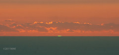
That was my hope during this morning's eclipse. Not to reunite star-crossed lovers, but to see the sun and moon at the same time. Sadly, the setting moon ducked behind some clouds in the last few minutes before the sun came over the horizon. I'm pretty sure I picked a good spot for the attempt though. Here's the closest I came to seeing them both (stitched in Photoshop from about six individual frames):
You'll have to click to see more than just some patches of blue and purple, though.
The kind of Eclipse I enjoyed watching
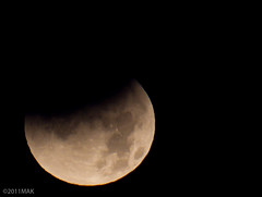
This morning's eclipse wasn't fully visible here in western Wisconsin, but the moon started to move into the earth's shadow as it set over the western horizon. The moon ducked behind a low bank of clouds, so I wasn't able to see if the sunrise could catch up.
It was about zero degrees outside - much too cold to make it truly enjoyable, but it was worth it - especially since there's not going to be another total lunar eclipse for a few years.

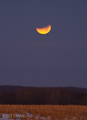
And this is what we started with (and what those of you around the Pacific ended with).

Friday, December 09, 2011
Kelly's book got a good write-up
Go over and read the review Kelly's book got over at SF Reviews. It's thorough, thoughtful, and, as Kelly said, the reviewer "gets it."
Did I mention I drew the maps? I probably did at some point.
Did I mention I drew the maps? I probably did at some point.
Aftermath of the Sand Castle Lab
My lab in the aftermath of the "Sand Castle Lab"

The plastic media used by LRRD for their Emriver stream tables is an excellent teaching tool for soil mechanics.

The plastic media used by LRRD for their Emriver stream tables is an excellent teaching tool for soil mechanics.
Refraction?
I've been thinking about refraction and how one of the professors I would TA for pointed out a major problem for the invisible man. If he was truly invisible, light would pass right through his eyes - and he wouldn't be able to refract light with his corneas to form an image.
Then I started wondering about fish - what's the index of refraction in fish? Is it different in freshwater fish versus saltwater?
"Clams with Laser Pointers" is the name of my 80's cover band.
Then I started wondering about fish - what's the index of refraction in fish? Is it different in freshwater fish versus saltwater?
"Clams with Laser Pointers" is the name of my 80's cover band.
Thursday, December 08, 2011
Thurs-Demo: The One with Frickin' Laser Beams
I've got a few demos cooking (or boiling up), but here's a quickie with the index of refraction. I used a ring stand and a few clams to hold some laser pointers above an aquarium.

Using Photoshop to measure the incident and refracted angles. Based on a reference I found online, the measured index of refraction compared to the expected values were off by less than 1%. Not bad for a quick and dirty setup. Check out how close I managed to get the lasers aligned, too.

On a side note several materials fluoresce in the blue laser light. So I put a few drops of fluorescent dye into the tank and waited for something interesting to happen.

Oh, and by the way - some of this refraction stuff is why you can get a "green flash" at sunset. You can find some more on the hyperphysics website at Georgia State and a detailed review of the phenomenon by Andrew Young.
When my wife and I were in Hawaii, I managed to see the green flash on three different evenings over the 10 days we were there - not a bad average.(darn, pics are on a different drive, so that will have to wait - sorry).
And now the flash:


Using Photoshop to measure the incident and refracted angles. Based on a reference I found online, the measured index of refraction compared to the expected values were off by less than 1%. Not bad for a quick and dirty setup. Check out how close I managed to get the lasers aligned, too.

On a side note several materials fluoresce in the blue laser light. So I put a few drops of fluorescent dye into the tank and waited for something interesting to happen.

Oh, and by the way - some of this refraction stuff is why you can get a "green flash" at sunset. You can find some more on the hyperphysics website at Georgia State and a detailed review of the phenomenon by Andrew Young.
When my wife and I were in Hawaii, I managed to see the green flash on three different evenings over the 10 days we were there - not a bad average.
And now the flash:
Tuesday, December 06, 2011
Testing some demos
Thurs-demos have been on pause as the mad rush towards the end of the semester takes its toll. I ought to be able to toss one up this week though. Here's some stuff that I've been checking into for the future...


Yes, that's a blue laser... so cool.


Yes, that's a blue laser... so cool.
Wednesday, November 30, 2011
Mapping the City of Tien: A palimpsest of culture and process
Today's topic: the city of Tien. Tien is the capital city in the Kingdom of Zhan - a whirling nest of high court intrigue, magic, assassins, and the occasional undead. You can read about it in the amazing Kelly McCullough's new book, which I blogged about mapping yesterday, too.
I want to point out my process for making the city map. My goal was less about topography and more about neighborhoods. Where is the Stumbles? How close is it to the Royal Docks? Where is the Ismere library in relationship to the Royal Palace and the River Zien? How do the canals provide transportation and sewer service?
And, summarily, how would all of this have accreted over the centuries as new places sprung up, old ones decayed or gentrified, and more and more people tried to use the space?
While I'm not a geographer, I do spend a fair amount of time thinking about how people interact with the landscape. Starting from a scanned sketch from Kelly, I knew where the major features were. In this case, I had to do less geologic creation, and more urban planning. I did know that there were four major hills - kind of like the seven hills of Rome. So my first thought was to figure out how those hills got there - this would give me geologic constraints on the locations of various streets and neighborhoods. Plus, I would illustrate the general topography and keep the detail for specific places and buildings named in the book. Since we had a river that flowed into the harbor, my first thought was to have the four hills as remnant high stream terraces, with the majority of the city built around the (heavily modified) floodplain or low terraces. But there were some plot devices used in the book that needed good bedrock cliffs. So I adjusted my terrace idea to be remnant bedrock highs, surrounded by the lower floodplain. Plus a remnant terrace on which to place the Royal Palace and a few other neighborhoods - these breaks in the flat-lying landscape often create neighborhoods in real cities (especially ones along rivers).

Here was my first pass at organizing the city landscape. I ended up symbolizing the hilly areas differently, but it gave me the layout of the major features.

Now came filling in the neighborhoods and implying that most of the city was a dense maze of city blocks - it's a lot easier to erase away the streets to define the general pattern. I didn't intend to draw every single building - that way would lead to madness...
With much of the street layout defined, I started to place a few important buildings and work out how I was going to show the reader where the hills were located. It's tricky. Many maps use hachure lines to display topographic information. But this didn't mesh with the way I had drawn some of the other features, so I played around with some possibilities. Besides - some of these hills were really steep bedrock cliffs, while others were just rounded and steeper than the surrounding plain.

This was too "smeared" and I also didn't think it would reproduce well as a halftone bitmapped image.

This was better - plus, I could show the ruggedness of the slopes.

So here's the city with the four major hills and the streets. I adjusted the canals so they would at least seem to have the potential to act as both a sewer and transportation system.
Tossing in some text, a few important buildings and a rough scale, here's the finished map.

Keep in mind that this map was being printed only 3" wide, so I gave prime location to the names, rather than specific features. A few tweaks to the final halftone so the grays would reproduce well and it went with it's sibling world map to the publisher. And now it's in print. That makes me happy. So go buy the book already!
Tuesday, November 29, 2011
Making a Map
Guess what? Today is the release date for Broken Blade, a new fantasy series written by my good pal Kelly McCullough. Having read the beta versions, I can say that if you enjoy fantasy novels and film noir, you'll enjoy these books.
Beyond reading the beta copy, I drew the maps used in the book. It's partly an homage to the maps in Tolkein's Hobbit and LOTR, but it's also done from the perspective of 1) A geologist who understands some aspects of how the geography of a region might evolve as a result of some underlying physical process and 2) a traveler or map-maker living in this fictional world, trying to convey what it's like to "be there."
I started with a fairly simple sketch map that Kelly drew up as he was outlining the story. From this, I drew a pencil & pen sketch of how I thought it should look. I scanned this map into the computer so I could adjust things in Photoshop - it's much easier to add text, move mountains (literally), and prep the map for publication as a digital image. Several years ago, I drew a map for a friend, and I had done everything in layers of tracing paper so I could adjust rivers, forests, etc. I much prefer the digital method.

Here's a scan of part of my pen/pencil sketch. I also worked on a map of the principal city, which took Kelly's original sketch and went straight into the computer.
Before going any further with line work, I wanted to make sure that I would draw mountains, hills, and rivers that behaved in a reasonable manner. In the real world, the geography is a function of climate, underlying bedrock, and elevation. I didn't have time to draw up a geologic map, but I had both likely climatic and geologic characteristics in my head when I sketched out a rough elevation map.

The rough elevation map: white=high elevation. This gave me a way to keep things organized - where the mountains should be, where rivers and lakes should be (so I wouldn't draw rivers that had to flow uphill)

Here's a detail that shows how I combined representations of mountains (in a semi-oblique view) with rivers.

And the finished geography portion of the map. I tailored the geomorphology to have some areas with fairly young, active topography, with areas of older, more mature topography.
Then there was the need to provide place names so that people reading the story could check the map to see where they were. I tried to keep large areas of negative space so that I could place text without having to contort it too much. But this is where digital map-making really helped - I could just select and drag an entire mountain or stretch of river and drag it out of the way to accommodate text. Or I could curve text, tighten the kerning or otherwise keep the text legible (although at published size, about 3" wide, nearsighted readers may have some difficulty).

And the finished project, complete with labels. And in print, it looks even cooler (since there's an awesome story that unfolds around it).
So go get a copy!
Ben - here you go:

Monday, November 28, 2011

Sunday, November 27, 2011
Holiday Decorations
I put up some holiday decorations today. Although I may have gotten things turned around a little bit.


Subscribe to:
Posts (Atom)