Friday, September 22, 2006

Where have all the snails gone?


The above map I put together based on the summary paper by Jass (2004). In this paper, she echoes the call of Hubricht (1985) and others that much of the upper midwest is woefully undersurveyed for snail abundance. Notice the large number of Wisconsin counties with fewer than five land snail species reported for that county. The most populous counties (Dane, Milwaukee, Brown), those with state universities within them, have the highest abundance. This is definitely not a result of natural distribution - I've found snails in counties that have no official records. It likely reflects the fact that the researchers concentrated their efforts close to home. What does this mean? If we want to know the true extent of the distribution of snails on this continent, we need more people looking for snails. They are an excellent indicator species and have a great deal to tell us about the modern (and ancient) environment if we'd only stop to listen.

Thursday, September 14, 2006

Science and Reason: Philosophia Naturalis #1

Science and Reason: Philosophia Naturalis #1

Sorry for any repeat links - I'm trying out a remote linking option on blogger. But hey, this is the first carnival for this one, so it deserves two links :)

Carnival Hat Trick

In short order, I have three posts at three different carnivals - including a brand new carnival, sure to please all you physical science types.

The first is over at The Tangled Bank #62:


A travel bingo edition complete with drawings by the host. Very cool - and check out the rest of his site - very talented artists over there.

Next up is I and the Bird #32:


A fellow north-woodser gathers a slew of fascinating posts about birds. Who knew that there was another naturalist blogger in this area. How cool is that?

Finally, the brand new science carnival, Philosophia Naturalis #1:


Science and reason has something for all you chemists, physicists, and non-biological earth science types. Check it out - and you geo-bloggers better step up to the plate!

Whew! I'm spent. See you for the next round in a couple weeks...

Tuesday, September 12, 2006

The Driftless Area, pt. 2

How did the Driftless Area form?


In the previous post, I talked about the what and where of the Driftless Area. This is a brief discussion on how. During the last Ice Age, the thick sheets of ice that covered much of the northern part of the US and nearly all of Canada went around the Driftless Area. How did that happen? There are a couple of primary thoughts regarding this. The first and most likely is a result of the highlands of northern Wisconsin and the Upper Peninsula of Michigan (UP). The second is slightly more complex and factors in the amount of liquid water at the base of a glacier. Liquid water? At the base of a glacier? Yup - and I'll mention why later in this post.


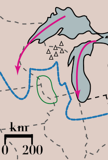
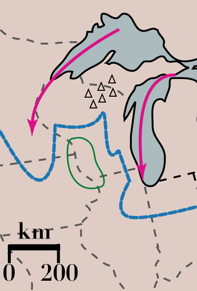
The most cited explanation (e.g. Syverson and Colgan, 2004) for why the glaciers bypassed the Driftless Area is because the area in northern Wisconsin and the UP is topographically higher (even pre-glacier) than the surrounding region (see figure on the right). This diverted the glaciers around them, and slowed its movement enough to prevent the ice from covering the Driftless Area (green circle). A subset of this idea is that while lakes Superior (upper left) and Michigan (lower right) were not as they are today, they were likely topographic depressions that would have acted as channels that encouraged ice to flow through them, bypassing the area inbetween. These hypotheses are quite robust - they explain how the Driftless Area avoided being covered by ice, and are backed up by a great deal of geological evidence such as glacial deposits, glacial striations on bedrock, and computer modeling.

Another possibility is that the porosity of the bedrock in the Driftless Area absorbed the liquid water at the base of the glacier, and prevented it from flowing into the region, "gluing" the ice to the ground. So how does water get to the base of a glacier? One is that this far south, there was a considerable amount of melting going on, even in the winter (it is warmer down here than it is way up north, after all). This water flows down through the ice and often finds its way into (or creates its own) channels along the base of the glacier. Another way is through pressure. With increased pressure, the temperature required to melt ice decreases. At the base of the glacier the pressure is sufficiently high enough, and it is not cold enough, so that water can exist. This film of water acts much like the film of water beneath a pair of ice skates - reduces friction and allows the ice to flow faster. No water, no flow (or very, very little). Hence, the Driftless Area, with its porous bedrock allowed water to get away from the glacier, and prevented the ice from moving.

This film of water is also what alows modern glaciers to surge, sometimes a hundred meters or more in a day. The water reduces friction so quickly that the ice just shoots down the valley. With increasing global temperatures, the chances of more glaciers surging increases. Without increased input of snow and ice near the head of the glacier, it could disappear all the more quickly. Granted, this is a simplified prediction of a complex process, but in basic terms, it's one of the concerns glaciologists have as the earth's temperature continues to rise.

The Driftless Area, pt. 1

What is the Driftless Area?


Simply put, the Driftless Area is the region in Southwestern Wisconsin, Southeastern Minnesota, Northeastern Iowa, and Northwestern Illinois that was not covered by the late Wisconsin glacial ice and has a characteristically rugged topography. The broad plateau of paleozoic bedrock (mostly limestone, dolostone, and sandstone) is deeply dissected by the river drainage systems here because this area has been exposed to weathering for much longer than the surrounding area. Glaciers act as a kind of eraser - resetting many geomorphic features by planing off the high regions and depositing a thick blanket of glacial sediment, referred to as a 'ground morraine.' The older name for undifferentiated glacial sediments was 'drift,' hence the name for this region.

map data available from: http://seamless.usgs.gov

My research revolves around looking for snails buried in alluvial sediment within the Driftless Area. These late Pleistocene-aged snails were living in this region while there was ice less than 100 kilometers away. There's evidence for permafrost - and permafrost requires a mean annual temperature below freezing. While permafrost would inhibit the growth of trees (too cold, frozen ground prevents rooting), there are snails in the southern part of the Driftless Area that feed primarily on deciduous trees. This suggests that the permafrost was not continuous in the south, but perhaps it was farther north. One of my goals is to describe where different snail species are present and where they are absent (although absence of evidence is not exactly evidence for absence). Significant changes in the distributions of various species could indicate where there might have been some trees hiding from what must have been a cold and rugged climate. So maybe it wasn't as cold and nasty as people think - at least in some places.

So, why did the glaciers miss this part of the country? That's a post for another day...

UPDATE: Part two is up.

It's right around the corner

Fall is fast approaching. The birds are in bulk-up mode, preparing to either tough out the snow and cold, or head on a long journey south to fairer climes. Berries and fruits are still in ample supply, and all maner of fowl are taking full advantage of it. Here's a photo I snapped a few years back when I was down on UW-Madison's campus:


The birds up here on the north shore are just as busy (even getting started a week or two earlier), and the hawk migration is gaining momentum. Soon, kettles of broad-winged hawks, turkey vultures, and bald eagles will be soaring high over my house. I can't wait.