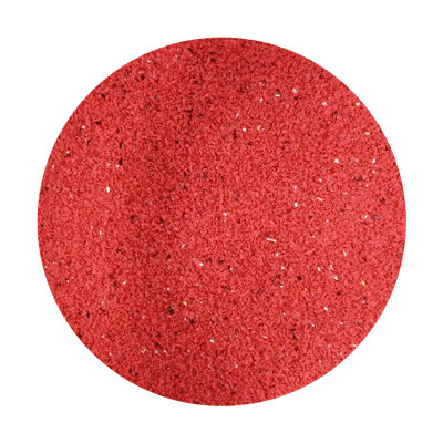
I'm still tweaking the grain size analysis. Instead of a visual estimate, I took a picture of the sieved fraction and measured the proportion of pixels in different color ranges. By selecting a "color range" I can find out how many pixels are yellow, compare that to the total number of pixels and get a much more refined estimate.
Here's an example - I masked off a circle to isolate just the sieved sediment.
Using the color proportions measured with Photoshop (ImageJ also can do this), I modified the histogram to represent each color fraction.
Just for fun, here's an animated GIF showing each fraction (Pan-#10)


Cool, Is there a guide for how to do this in ImageJ?
ReplyDeleteHere's a summary of some possible methods:
ReplyDeletehttp://rsbweb.nih.gov/ij/docs/menus/analyze.html
Since the program was designed for this kind of work, it might be more easy and intuitive than photoshop's workflow.
It appears it will do much more than what I have been using it for. Thanks
ReplyDeleteI'm an imageJ novice (actually I think I'm just going to be a Fiji novice instead). Given that, I don't see an easy way to do the color analysis that you did with photoshop. IJ decomposes the RGB into individual grey scale bands and that makes analysis of anything but primary colors difficult. There are some image analysis plug-ins out there where you "train" the computer on what is red, yellow, ect. And then have it find all of them, but this is cumbersome. The technique developed in Lewis et al paper "An automated system for the statistical analysis of sediment texture and structure at the microscale" might be useful. Any ImageJ gurus out there? So far I've found the Spatial Analyst Extension of ArcGIS the easiest to use - but then again, I actually kind of know my way around that software.
ReplyDelete