Showing posts with label fluvial geomorphology. Show all posts

Saturday, March 09, 2013

Emriver color-coded sediment, un-mixing the media.

My soil mechanics students had their grain size analysis lab this week. It's fun - they get to analyze granular materials by playing with sand. Specifically, the plastic sand that comes standard with the Em2 stream table. Last year I ran the standard media through a stack of sieves. This year, I ran the color-coded plastic media through the sieves.

These gradation curves are a quick way of describing and comparing different sediments. The standard media (blue curve) is different by having a little bit less material between 2 and 1mm in size (but more material larger than 2.4mm), and quite a bit more fine material around 0.5mm. The horizontal axis is in microns (1 mm = 1,000 microns) and it's on a log scale, because there's such a huge range in diameter.


Here's a frequency curve showing the relative proportions of various size fractions. The "Phi Value" is another way sedimentologists scale the wide range of particles (Phi Value = -log2diameter in mm). So the Phi Value of a sand grain 1 mm in diameter is zero. Notice the big bump in the standard media between 1.5 and 2 phi. My own speculation is that as the material moves around, the big particles grind themselves down into particles around this size (0.3mm).

What you can't see, and what is the true brilliance behind the color-coded material, is how moving water separates the color-coded particles into various color patterns. You can also see the colors in the sieve separates, too.

CIMG1244


So let's look at the distribution of grain sizes in the color coded media a little more closely:


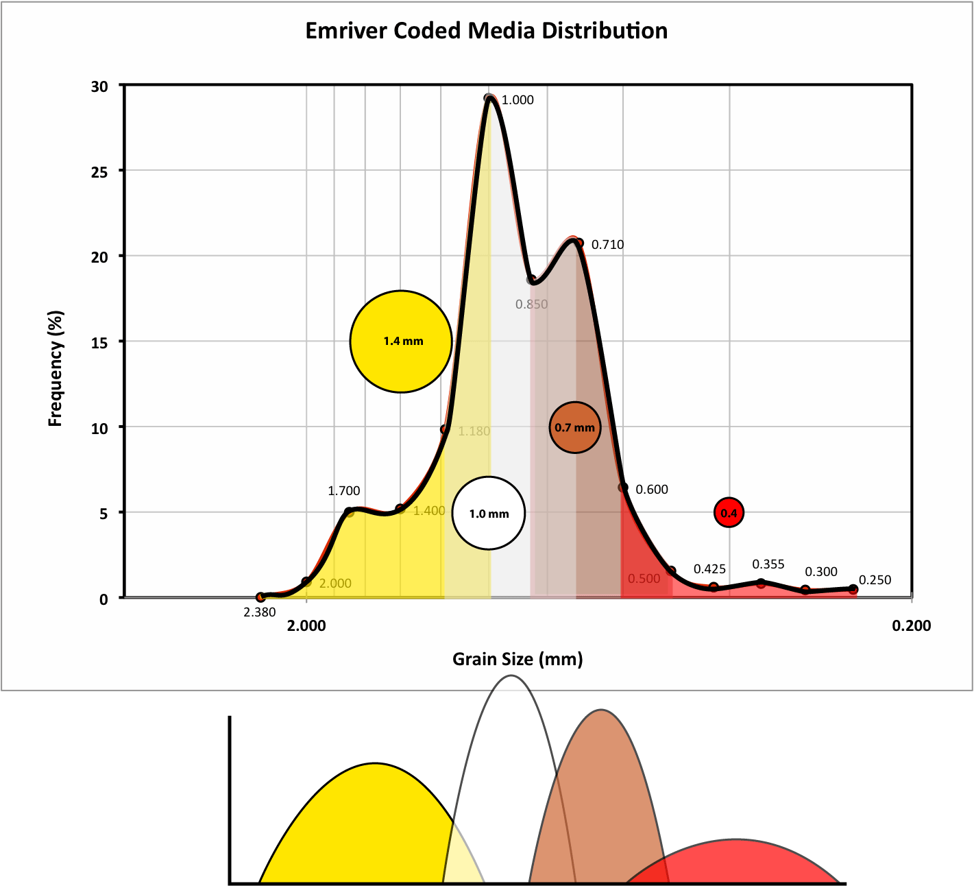
 I like the distribution graph (given a little bit of visual "boost" by arbitrarily smoothing the line graph in Excel) because it hints at the formula for the Emriver sediment. There are four "bumps" that correspond to the sizes of the four different colors (Yellow = 1.4mm, White = 1mm, Brown = 0.7mm, Red = 0.4mm).

Here's an overlay of the color fractions - the curves below represent approximate distributions of each individual fraction.

Here's a picture from Steve, the big guy at LRRD's blog (Riparian Rap), showing the Em4 being filled with unmixed coded media. Given that some of the smallest yellow particles are smaller than the largest white particles, un-mixing the coded media into perfect color fractions isn't possible by mechanical means alone.

My plan now: use the grain size distributions to create "color facies" for the plastic media - providing a way to do grain size analysis with time lapse photographs.

Update: talking with Steve over email, I realized that the color fraction "curves" as drawn above may imply more quantitative "knowledge" than I really have about the distribution of each color. Here's a histogram, with the color fractions approximated by visually estimating the proportion of different colors visible in each container (vertical scale is in grams):


Thursday, March 07, 2013

Slow-Mo Sedimentation: When Stokes' Law Doesn't Apply

Thanks to the ever helpful folks at LRRD, the colored sediment for my lab's Em2 arrived last week. I shot some high speed video of a scoop falling through water. Based on the results, I tried again with the help of my colleague Todd Zimmerman. We tried a few different colored gels on the translucent backdrop, but the first one that I used, a nice deep blue, works the best. I think it's because of the red-orange hues in all of the sediment particle sizes contrast well with the blue.

Colored sediment: when Stokes Law does not apply from Matt Kuchta on Vimeo.

Contrast this video with the footage we captured a few years ago of ball bearings falling through corn syrup:
What a Drag! Falling Through Syrup from Matt Kuchta on Vimeo.

The single ball bearing is a good example of how Stokes' Law works. I blogged about it before, too. But the first video shows many particles. These particles are banging into each other, the combined mass of the particles is also pushing the water around in turbulent eddies. Stokes' Law does not apply because the settling of each particle is hindered by interactions with other particles and the surrounding fluid. In these cases, we're often without a simple, elegant equation to describe what's happening. Instead, we have to rely on empirical observations. Such as the bedforms left behind in the sediments after the particles are deposited. In the end, however, many of the smallest particles are left behind to drape over the entire pile of material. So even in these chaotic, turbulent systems, Stokes' observations can still help inform us of these processes.


Tuesday, March 05, 2013

Emriver Color-Coded sediment in action

A little test run with the new color-coded sediment that arrived last week. It's so pretty!


CIMG1220

CIMG1221

I seem to recall some fluvial stratigraphy diagrams tossing around facies patterns that look strikingly similar.

CIMG1236

I'm rather excited about 3D facies mapping possibilities here. Too bad I have so many other irons in the fire. 

Wednesday, September 14, 2011

Connecting the dots.

I've been working on my presentation for GSA - which is part of my developing research into the fluvial geomorphology of the Red Cedar River in western Wisconsin. The picture below represents some of what's occupying my mind right now. The dots represent the elevation of stream terrace surfaces along the river valley. The y-axis is elevation in feet above sea level and the x-axis is horizontal distance (in meters) measured from the mouth of the Red Cedar River. I obtained the measurements in GIS, getting the elevations from a LiDar dataset and using the "measure" tool to get horizontal distance. The orange and green lines represent some possible interpretations for correlating the different terrace surfaces.


You can see that the two interpretations are quite different in some aspects. The orange lines are my primary interpretation - I focused on emphasizing terrace elevations that were parallel with each other. But, while it's tempting to correlate terraces so that they are parallel with the modern stream profile (blue dots at the bottom), this may not be the case. So, as an exercise in "changing my perspective," I drew the green lines by "squishing" the plot horizontally (extreme vertical exaggeration). This emphasized the possible surfaces that were not parallel.

Those of you with some training in fluvial geomorphology may have noticed another interesting feature. The sheer number of terraces along a 20 km reach of a relatively small river. I have probably over-interpreted some of this data; fourteen terraces, some separated by only six feet is probably the high-end estimate. Even with a more "conservative" correlation, there are at least eight terraces along this stretch of river. I'll let further exploration of that point (as well as my take-home message about the terrace profiles) wait until GSA - if you want to get the full story, come to my talk on Tuesday afternoon.

Tuesday, August 30, 2011

What I'm doing at GSA this year

It's that time of year again. Well, actually, it's about a month before that time of year, which is about 3 weeks earlier than usual. GSA is going to be held in Minneapolis, MN on October 9-12. Some of the geobloggers will be presenting, many will be attending. I know there is at least one planned meetup for the geobloggers to socialize and chat. Since I've got friends in the cities and live about an hour away, I'm grabbing a list of suggestions for your consideration.

I'm giving a talk on Tuesday at 3:05 about my research:

LATE QUATERNARY TERRACE AND LONG PROFILE DEVELOPMENT IN THE LOWER CHIPPEWA VALLEY

Session No. 210
Quaternary Landscape Dynamics Beyond the Ice Margin in the Upper Mississippi Valley: A Tribute to the Career of James C. Knox
Minneapolis Convention Center: Room L100DE
1:30 PM-5:30 PM, Tuesday, 11 October 2011


There's also an associated poster session - I had a student working with me over the summer and her research will be there.


One final note: there is a field trip (#442) through the UMV (Thursday through Saturday) organized by the same folks. In fact, it sounds like there's still room if you're interested in joining us for a few days of fluvial geomorphology and landscape evolution.