If you aren't moving at a snail's pace, you aren't moving at all. -Iris Murdoch
Pages
▼
Thursday, March 31, 2011
No shark jumping here!
I'm clearly punchy today...
And now for something completely different
Braaaaiiiins
This made my morning happier. Except for the downer of an ending:
If you look closely, you may notice "Birdchick" of the eponymous blog.
It's not April yet!
Already I've read a few parody blog posts. But it's not April 1st yet... In the morning, it's very hard to deal with the world before coffee. And these April Fools posts aren't helping. Funny yes. Making it easier to teach in 15 minutes, no.
Almost there...
Only 230 to go and it's not even 8am yet...
Maybe I'll have to write something witty. Or pithy. Or both.
Wednesday, March 30, 2011
Can I break 8K?
According to Blogger's web stats, I'm about 400 visits short of 8,000 for the month of March. Can I get 400 in a single day? Perhaps - if I get picked up by Boing Boing again or something...
NOVA's Japan Quake Episode
Just watched the NOVA episode about the Quake. Overall, I thought it was good. The science was pretty basic, but not incorrect. They showed a mind-numbing amount of human suffering. A bit of "tragedy overload," but given the scale of this disaster, it's hard not to portray it any other way.
It reminded me that this is how you emphasize the risk of geologic hazards. You don't wave your arms and say the earth is "ringing like a great brass bell." You can be just as dire and ominous with the facts as you can with speculation and hyperbole.
Is it too soon to call shenanigans?
I've been looking over some interesting earthquake science today. The first is the Nature Geoscience paper (wired.com summary here) about the statistical (and physical) lack of any evidence for major seismically "triggered" earthquakes far-afield. That is to say, a big earthquake along one plate does not appear to increase the chance for another big quake along a different boundary.
Then there's a guest blog by Christie Rowe about earthquake prediction and the unpleasant yet real situation of uncertainty.
Some of you may be familiar with the recent issue many of us in the geology community have taken with Simon Winchester's "comments" about California.
(screen cap from the Fox interview with Winchester)
Today, Donald Prothero (writing for skepticblog) has a blog post about another quake-quack, Jim Berkland. It got me wondering - are these two (Berkland and Winchester) connected? I did a quick search of "teh google" and didn't come up with anything directly linking them. Alarmists and conspiracy theorists have been buzzing about the comments both of them were making last week. They were both interviewed by Fox News. They both talk about the "four corners" of the Pacific Plate (a horse-pucky idea in the first place) and they both have undergraduate schooling in the geosciences. But I haven't found any coordinated effort between them, so it's more likely a case of convergence.
(screen cap from the Fox interview with Berkland)
This doesn't make things any less frustrating - there are real risks. There are real hazards. Arm waving and claiming persecution from mythical "powers-that-be" isn't helpful. There is nothing to suggest that either Winchester or Berkland have any real handle on the geological systems actually involved. Just an ambiguous pseudoscience of hyperbole and alarmism.
Thurs-Demo: The one that should have worked last week
This demo has been a long time coming. I came up with the idea back in '97 as an undergrad. We were looking at self-organized, critical systems and the 1992 Landers earthquake was brought up as a possible system where small perturbations may be enough to generate change. So I rigged up a demo - and it worked nicely. Now, 14 years later (yeesh - has it been that long?) I have this demo-a-week thing going on and I thought it would be a good idea to try it again. Especially given the recent interest in the Japan quake, my Earthquake Machine (El Temblor!) and the current brouhaha regarding remotely triggered seismicity and earthquake predictions. But my attempt last week was less than impressive.
I probably should have also existing bubbles being shaken loose as an additional factor in causing movement.
Some background: A magnitude 7.3 (ML) earthquake near Landers, California appears to have triggered seismicity in several locations in the western US - especially in areas with hydrothermal systems or sites with recent volcanic activity occurred such as Long Valley Caldera (Hill et al, 1993, Linde et al., 1994, Johnston et al., 1995). The epicenter of the Landers quake was several hundred kilometers south of the Long Valley Caldera - what these authors suggest is that bubbles within magma or hydrothermal systems were "shaken loose" as a result of the earthquake passing through the fluid and these bubbles created extra pressure that was exerted on the crust, inducing seismic activity.
It's interesting to note that Linde et al (1995) speculated that there may have been volcanic eruptions triggered by other regional earthquakes including 1707 eruption of Mt. Fuji (Hoei M=8.4), Mt. Calbuco in Chile - 1960 (M=8.6), and the 1980 "Pozzuoli crisis" after the (M=6.9) Iripina quake. I found this interesting, especially given the recent set of posts by Jessica Ball (Magma Cum Laude) discussing the possibility of volcanoes triggering earthquakes (Part 1 and Part 2).
Sources:
Soda Pop Earthquake from Matt Kuchta on Vimeo.
I probably should have also existing bubbles being shaken loose as an additional factor in causing movement.
Some background: A magnitude 7.3 (ML) earthquake near Landers, California appears to have triggered seismicity in several locations in the western US - especially in areas with hydrothermal systems or sites with recent volcanic activity occurred such as Long Valley Caldera (Hill et al, 1993, Linde et al., 1994, Johnston et al., 1995). The epicenter of the Landers quake was several hundred kilometers south of the Long Valley Caldera - what these authors suggest is that bubbles within magma or hydrothermal systems were "shaken loose" as a result of the earthquake passing through the fluid and these bubbles created extra pressure that was exerted on the crust, inducing seismic activity.
It's interesting to note that Linde et al (1995) speculated that there may have been volcanic eruptions triggered by other regional earthquakes including 1707 eruption of Mt. Fuji (Hoei M=8.4), Mt. Calbuco in Chile - 1960 (M=8.6), and the 1980 "Pozzuoli crisis" after the (M=6.9) Iripina quake. I found this interesting, especially given the recent set of posts by Jessica Ball (Magma Cum Laude) discussing the possibility of volcanoes triggering earthquakes (Part 1 and Part 2).
Sources:
Hill et al (1992) Seismicity in the Western United States Triggered by the M=7.3 Landers, California Earthquake of June 28, 1992, Science vol. 260, pp. 1617-1623.
Linde et al (1994) Increased pressure from rising bubbles as a mechanism for remotely triggered seismicity, Nature vol. 371, pp. 408-410.
Johnston et al (1995) Transient Deformation during Triggered Seismicity from the 28 June 1992 Mw=7.3 Landers Earthquake at Long Valley Volcanic Caldera, California, Bulletin of the Seismological Society of America, vol 85, no. 3, pp. 787-795.
This is what a shield volcano looks like
Tuesday, March 29, 2011
Pretty
We had a high-speed video camera representative come visit our department and demo a camera. I like the way the flying sand kind of floats along at 10,000 frames per second.
Slow Motion Test Footage from Matt Kuchta on Vimeo.
So when can we set our feeder up?
Hummingbirds are migrating north. They're being reported in Indiana already! That's cool. But we still have snow up here in Wisconsin, so I don't know when they'll show up. Some locals have reported seeing bluebirds already. It's time to start prepping the warm-weather feeding setups. Hummingbirds are one of my favorite warm-weather indicators.
One of last year's visitors (click to embiggen)
It's a pretty sweet gig, if you can stomach it
I've been thinking - it must be nice to be a young-earth creationist. You never have to worry about data, because the geological record is going to be a testament to the bible. No matter how contradictory the fossil record, isotopic dating, geologic structures and processes may seem, they will always testify to the literal truth of the bible. One hundred percent. Although which specific passages written by which particular tribe and translated by which particular white guy over fifteen hundred years later may sometimes be in doubt.
That got me thinking about how a creationist would go about writing grants and papers. Clearly, the hard part about science (the figuring-out-what-it-means part) is already done for you. The whole system is simple Kabuki Theater - it's just a matter of going through the motions. There is no science - but there is a pretty sweet meal ticket. You get paid some amount of money to walk around, looking at rocks. Take some pictures, half-heartedly mimic some geologist's methodology - you may already have the report written up, save for the blank spaces in the document waiting to refer to some specific roadcut you haven't picked out yet.
I was looking at some YEC posters at the Geological Society of America meeting a few years ago. I couldn't figure out why they chose the places they did. There wasn't any geological hypothesis that dictated a "dig here" approach. Instead, the sample locations followed major highways. It had the appearance that they just took a road trip, hopping out of the vans long enough to stretch their legs and walk over to an outcrop near the highway. Maybe they'd grab a sample (there wasn't any stratigraphic meaning to where the rock came from - it could just as easily been some landscape decoration near a truck stop) or snap a photo. Then back into the van.
In the end, it becomes simply a paid vacation. It's not much different than a family camping trip - aside from the fact that you're not allowed to actually find anything new. Or think about stuff. If I didn't respect myself and my profession so much, it would be a pretty sweet fall-back gig. If I can't hack it among real scientists, at least I could dupe these folks...
To be honest - it's the not knowing I find exciting. It's the mystery. The chance to create one's own synthesis of the physical world, independent of anyone else. It may or may not be correct. It may or may not work. But, if you're lucky, you might get to change the way people think (about something small, or about something big). That's true power. That's true learning. That's science.
115 Days
Our local meteorologist made a comment this morning that we have had at least a trace of snow (ca. 1 inch) on the ground for the past 115 days. That's almost 1/3rd yr. It feels like forever, though. Oh well - you could always try my albedo demo on a grand scale:
Brrrr.
ALBEDO from Matt Kuchta on Vimeo.
Brrrr.
Monday, March 28, 2011
Nice View of Pu'u 'O'o crater
There's a great view inside the Pu'u 'O'o crater right now. The crater has been re-filling with lava over the last couple of days. This evening the gas and vapor parted, leaving a lovely vista.
Oscillating Buildings
Tim (fellow geo-badger-blogger) shares stories from a recent spring break trip to Seattle. He's got some cool video taken from the pacific northwest seismic network that shows the effect of periodicity on buildings. I'll have to remember that reciprocating wheel system for future toying-around-with...
Albedo!
Not an official Thursday release (because I'm still working on fixing the failure from last week). But, I couldn't pass up an opportunity to demonstrate the concept of Albedo:
ALBEDO from Matt Kuchta on Vimeo.
Thursday, March 24, 2011
He who lives by the demo...
I love demos. They're fun. When done properly, they teach. When they fail - the students still learn something. I learned that my coefficient of friction was way off for the demo that I had planned. Oh well. Perhaps there's something to be learned while I mop up the water all over the floor...
Wednesday, March 23, 2011
SNOW?!?! Do Not Want.
Yesterday it was very rainy and dark. Coming home from work, the raindrops had little ice crystals. Then there was wind and hail. And we went to bed with thundersnow. Thunder. And Snow. Together. Crazy. So I wake up to this. Joy. Don't get me wrong - I don't mind the cold and snow (at least until about February 20th). But c'mon - I want to get my students outside.
Curses. We managed to get caught by the late March snowstorm. We've got about 4-6" on the ground in western Wisconsin and more coming down today. This is not what I wanted - I was hoping my students would be able to get out and use the soil probes this week. I think we'll be lucky to even get outside next week... oh well. That's late winter/early spring around these parts...
Tuesday, March 22, 2011
What not to write
Chris Rowan has a good point about baseless, sensational predictions regarding earthquakes.. I was alerted to the article in question last night. I think I may have to include a "just in time" in-class activity regarding these two articles in my class tomorrow.
Update:
Andrew at About Geology provides some links and a review of one of Winchester's books.
Natalie Wolchover has another good, detailed tear-apart of the Newsweek thingy.
Update:
Andrew at About Geology provides some links and a review of one of Winchester's books.
Natalie Wolchover has another good, detailed tear-apart of the Newsweek thingy.
Booster Engine Retrieval - Neat Video
Ever wonder how they pick up the solid rocket boosters after a shuttle launch? NASAtv posted this series of clips. I really like their method of floating the entire booster - they just pop a cork in the back end and pump out the water.
I can also see why NASA is leaning towards expendable launch vehicles - you'd save a lot of money (time, equipment and personnel) if you didn't have to run out and pick up the engines each time you sent something into space. Plus the vehicle wouldn't need to be so extensively engineered. Not that I'm not a fan of the shuttle concept - I don't think regular, private and commercial space travel is going to function without some way of "hopping in your car to pop round Saturn."
Did you see the tumbling boosters in free-fall near the beginning of the clip? It gives you a great perspective on the ballistic trajectory they follow (at least after they've done their job).
Monday, March 21, 2011
Geomorphically "Correct" Art, Part Two
Steve Gough over at Riparian Rap has an ongoing series of geomorphically "incorrect" artwork. In that vein, I'm producing some maps for my pal Kelly McCullough's new book series (coming out in December BTW).
I thought I'd share some of the maps. It's fun playing "what if" in terms of landscape geology. Plus, it gives me a chance to exercise my drawing skills:
(click to embiggen)
Here's the "world" map - the biggest challenge was keeping the countries and cities in the same location relative to each other (determined by the author), while portraying the geomorphic features in a reasonably accurate fashion. That involved placing the rivers in patterns that showed proper downstream morphologies and drainage patterns, coastal features that reflected some river/shoreline processes, and adding a different kind of "mountain" range to the northwestern area of the map. I thought placing some Karst towers would be something different, compared to the mountains that are usually drawn.
(click to embiggen)
The city map (in progress), has to balance a sense of urban development history (old neighborhoods, new ones springing up and gentrified areas) superimposed onto a landscape that had some plot-relevant hills. I placed some neighborhoods on river terraces to to justify the higher hill tops (left behind as the river eroded downward).
The post that thanks everybody for the signal boost.
My earthquake machine from last week was picked up by Boing Boing today. It's resulted in somewhat of a boost to my blog traffic (by an order of magnitude).
I like the 2nd comment on the Boing Boing article:
What does that say about me, I wonder...
The post was also picked up by Vernier - the company that makes the force/acceleration sensors used in the videos.
There's also the herd of geobloggers and geotweeps that helped push this through the 'tubes' including Anne Jefferson and Chris Rowan at Highly Allochthonous, Steve Gough at Riparian Rap, and Brian Romans at Clastic Detritus.
I like the 2nd comment on the Boing Boing article:
So what I get from this is that if we get rid of the big mean guy with the beard who keeps pulling us around we wouldn't have earthquakes? -anon.
What does that say about me, I wonder...
The post was also picked up by Vernier - the company that makes the force/acceleration sensors used in the videos.
There's also the herd of geobloggers and geotweeps that helped push this through the 'tubes' including Anne Jefferson and Chris Rowan at Highly Allochthonous, Steve Gough at Riparian Rap, and Brian Romans at Clastic Detritus.
Saturday, March 19, 2011
The Physics of the Supermoon
Okay, I was going to try and post this last night, but there was some strange force pulling me away from my computer. It seems to have subsided, and I can now present to you the basic math & physics behind the super moon. Greatly simplified, but detailed enough to show the primary forces and stresses at work (adding more detail would not yield drastically different values in terms of magnitude).
So, to sum up. There is a calculable difference in gravitational pull by a moon at perigee. But the sum-total of the changes produce just a few thousandths of a percent change within the first kilometer of the crust. As you get deeper, the internal forces from the Earth quickly grow and the external influences from the moon quickly recede. No system that isn't "on the verge" (that is, any tectonic system that will likely fail soon anyway) is very likely to do much.
Also, check my pictures from yesterday for a desktop wallpaper-sized image for your very own...
Friday, March 18, 2011
That's no moon, it's Hyperbole!
Can't you feel it? Can you sense that 0.007% increase in lunar gravitational tugging? It's right outside my window, right now.
Is it just me, or might other planetary bodies benefit by giving them underpants? (And no jokes about Uranus...)
Here's a nice big version for your computer - so you can always feel the super-lunal pull of this event.
UPDATE: Check new post on the math behind the myth.
Some more Earthquake Machine Data
Yesterday's Earthquake Machine demo yielded some nice data. Some of the force and acceleration graphs show distinct events immediately prior to a large slip event:
y-axis: Force (red) and acceleration (blue); x-axis: time (about 0.5 seconds per tick mark)
Unfortunately, nothing really showed any decent "aftershock" activity. It may be that the time interval I was measuring wasn't small enough. Or, the friction (strength) of the material was enough to avoid any noticeable aftershock behavior. I'll have to try using different "rough" substrates - perhaps I can generate aftershocks if my friction surface is sufficiently unstable. (Pea gravel, anyone?)
Thursday, March 17, 2011
Thurs-Demo: The one with the Earthquake Machine
There is a Universal Truth (tm) related to teaching geoscience: there will always be a current event to point to. We live on a dynamic planet. Things move - sometimes undesirably. Japan is suffering from one of the strongest earthquakes in recorded history. Added to this are the compounded damages from the tsunami and the nuclear reactor failures. There are plenty of good discussions of the specifics behind the Sendai Earthquake.
Anne Jefferson at Highly Allochthonous has a good blog roundup on some of the events.
Chris Rowan (also of Highly Allochthonous) has a good rundown on the continued aftershocks of the Sendai Quake. He's also got a description of the kinematics of the quake. It's especially nice if you're trying to rectify those "beach balls" with the crustal block diagrams...
Callan Bentley's Mountain Beltway has a good post highlighting the GPS displacement vectors (distance and direction of motion) from Japan. He also provided a great initial summary of the quake.
Jessica Ball at Magma Cum Laude (one of my favorite blog titles) describes a few reasons why there are tenuous links between earthquakes and eruptions.
As I said earlier: it's like trying to pop a zit on your forehead by clenching your buttocks.
But back to the Sendai Earthquake. How to use this as a "teachable moment?" First, we can provide ways to help monetarily (through the Red Cross or similar) - although I would argue that Haiti is still worse off because of their lack of resources and infrastructure to help themselves. We can also educate people about earthquakes - perhaps by providing educated citizens, we can all benefit from better policies and systems in the future (hear that, gov. Walker?). Not just the dangers and hazards, but their underlying mechanics - how do they "work?"
So let's break things down a little bit. What are the forces at work here? We have tectonic forces, pushing the pacific plate beneath the island arc of Japan. The weight of the island arc pushes against the subducting pacific plate and creates a resisting, friction force that opposes the tectonic force driving the plates. When all forces are equal, nothing moves. As long as the friction force opposes the tectonic force, the plates will not move. But eventually, the applied tectonic force exceeds the friction force, and the plates move. This movement shakes the crust and releases energy (seismic waves) that travels through the earth. The more sudden and longer the movement, the stronger the shaking/earthquake. We can simplify this with a "free body diagram" of the forces involved (greatly simplified, but a decent first approximation).
To simplify this further, and bring the mechanics of the system into the classroom, there are several designs that use a brick on a spring. Pulling on the spring applies a tension force on the brick, but the brick does not move until the tension exceeds the friction force between the brick and the table (or sandpaper, or whatever). The forces are oriented in the same direction. Technically, the more analogous setup would be to have a compression spring, driven by a screw mechanism, since tectonic forces are more often compressive forces, not tension (but the direction and elastic behavior of the spring is still reasonably close).
The friction force is determined by the "Normal Force" (FN), which acts perpendicular (normal) to the surface and a "coefficient of friction." The greater the normal force, the harder the object is to move (try moving a refrigerator - and then try moving the box the fridge was shipped in). In addition, the coefficient of friction is a dimensionless number that describes how easy or hard it is to slide to objects past one another. Ice has a low coefficient, sandpaper has a relatively high coefficient.
For our "Earthquake Machine," the friction is provided by the brick and the sandpaper. The tectonic force is applied by pulling on the string (which is attached to the spring). The spring transfers the tension to the brick. Once the "tectonic" force exceeds the friction force the brick will slip forward - but only a short distance. The friction causes the brick to slow down and the applied force drops. The spring accumulates some of the tension by deforming (strain), then the accumulated strain can be released. When the spring's force diminishes to that less than the friction force, the brick stops moving; it sticks. The strain on the spring increases again until another slip. This is often referred to stick-slip behavior and is why many active faults don't shake all the time.
Here's the video:
I named mine "El Temblor!" I need to find some images of mexican wrestlers to paste on the sides and the brick to liven it up, I think. I designed mine to be easy to watch the brick, simple to construct, and cheap. Sort of a minimalist Earthquake Machine that I then loaded up with electronic sensors to graph some data (it's not SCIENCE until you graph some of the data...).
Let's look more closely at the force and acceleration data for one stick-slip set:
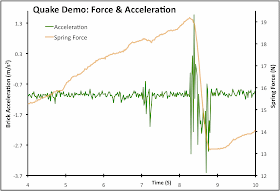
I was trying to keep my stress rate (winding up the spool) constant. You can see that the tension force (orange line) increases until the brick slips - releasing a bunch of accumulated tension stress. As the stress is released, the brick accelerates forward (green line). The brick slows down due to friction, which is why the acceleration graph goes into negative values. By adding a few data-logging tools (LoggerPro materials in this case), we can better see the magnitude of changes in the system. Plus, we now have a way of understanding what geologists are measuring before, during, and after earthquakes.
For a seismologist (the earthquake-studier), we can estimate the stress acting on rocks by measuring the relative movement between to pieces of crust. Places where the crust is moving tells us the stress is not accumulating. A lack of movement between plates of crust tells us the stress is being stored up (winding up the spring, so to speak). How much stress is accumulated can be estimated by the behavior of the rocks themselves (the strength of the spring) and the movement that should have occurred (how much the spring is deformed).
We don't know exactly when the crust will move, but we can provide a reasonable estimate of how strong the likely earthquake will be when it does move. If we're really lucky, we have hundreds (or thousands) of years of data that tells us how frequent earthquakes are in the region. So we may not know the hour, day, or even year - but we can at least point to areas that have a greater potential to move within a few decades or so. Given that cities are designed to last for many years, this is a pretty good estimate of risk for any particular city. Those governments with the capability and motivation to do so can plan for these earthquakes by mandating building codes, proper engineering, planning for disasters and so on. Japan's building codes likely saved tens of thousands of lives last friday.
So how can we apply our model to other situations? Take a look at this graph:
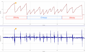
There are distinct periods of "stick" and "slip." The maximum stress accumulated was relatively constant, although there were a few slips near the beginning and end that were bigger than those in the middle. The friction was greater at the beginning and again at the end. So we have stick-slip movement here, while it more-or-less "creeped" along for part of the middle.
Here's another image:
Here we have another pattern. Mostly medium-sized slips until the very end. In the real world, these slips might represent the historical record of a medium-ish earthquake every century or so, and then a very big quake (arrow). Looking at the historical record, seismologists might decide that the "normal" pattern of medium-sized quakes had ceased and something was sticking more than it had been - making a stronger earthquake more likely. Note also the small accelerations (quakes) that don't interrupt the general increase in accumulated stress - not every quake reduces the possibility for another one.
That's not to say the big quake was "overdue." While our understanding of the model is very good, there may be other factors - perhaps the stress was being relieved somewhere else. Or perhaps the rocks aren't strong enough to store that much elastic energy. But it is never overdue.
Earthquakes are like wizards - "they arrive precisely when they mean to."
So what is the "spring" in our model? The rock itself. Rock has some elastic characteristics that allow it to store energy and then release it when the strength of the material is exceeded. I blogged about the elastic rebound theory earlier by using spaghetti noodles.
Update for Steve:
Here's a link to the pasta mechanics post. (PS - I'm probably going to write another "geomorphically correct art" post this week)
UPDATE 2: Thanks for the pickup from Boing Boing and Vernier.
For those of you who are interested, the equipment was the low-g Accelerator and the dual-range force sensor. I'm not sure who else makes comparable equipment, but you could also rig up a standard spring scale and use some kind of "wobbly" thing on the brick (like a thin wire, or cup of water) to show the magnitude of movement.
Anne Jefferson at Highly Allochthonous has a good blog roundup on some of the events.
Chris Rowan (also of Highly Allochthonous) has a good rundown on the continued aftershocks of the Sendai Quake. He's also got a description of the kinematics of the quake. It's especially nice if you're trying to rectify those "beach balls" with the crustal block diagrams...
Callan Bentley's Mountain Beltway has a good post highlighting the GPS displacement vectors (distance and direction of motion) from Japan. He also provided a great initial summary of the quake.
Jessica Ball at Magma Cum Laude (one of my favorite blog titles) describes a few reasons why there are tenuous links between earthquakes and eruptions.
As I said earlier: it's like trying to pop a zit on your forehead by clenching your buttocks.
But back to the Sendai Earthquake. How to use this as a "teachable moment?" First, we can provide ways to help monetarily (through the Red Cross or similar) - although I would argue that Haiti is still worse off because of their lack of resources and infrastructure to help themselves. We can also educate people about earthquakes - perhaps by providing educated citizens, we can all benefit from better policies and systems in the future (hear that, gov. Walker?). Not just the dangers and hazards, but their underlying mechanics - how do they "work?"
So let's break things down a little bit. What are the forces at work here? We have tectonic forces, pushing the pacific plate beneath the island arc of Japan. The weight of the island arc pushes against the subducting pacific plate and creates a resisting, friction force that opposes the tectonic force driving the plates. When all forces are equal, nothing moves. As long as the friction force opposes the tectonic force, the plates will not move. But eventually, the applied tectonic force exceeds the friction force, and the plates move. This movement shakes the crust and releases energy (seismic waves) that travels through the earth. The more sudden and longer the movement, the stronger the shaking/earthquake. We can simplify this with a "free body diagram" of the forces involved (greatly simplified, but a decent first approximation).
To simplify this further, and bring the mechanics of the system into the classroom, there are several designs that use a brick on a spring. Pulling on the spring applies a tension force on the brick, but the brick does not move until the tension exceeds the friction force between the brick and the table (or sandpaper, or whatever). The forces are oriented in the same direction. Technically, the more analogous setup would be to have a compression spring, driven by a screw mechanism, since tectonic forces are more often compressive forces, not tension (but the direction and elastic behavior of the spring is still reasonably close).
The friction force is determined by the "Normal Force" (FN), which acts perpendicular (normal) to the surface and a "coefficient of friction." The greater the normal force, the harder the object is to move (try moving a refrigerator - and then try moving the box the fridge was shipped in). In addition, the coefficient of friction is a dimensionless number that describes how easy or hard it is to slide to objects past one another. Ice has a low coefficient, sandpaper has a relatively high coefficient.
For our "Earthquake Machine," the friction is provided by the brick and the sandpaper. The tectonic force is applied by pulling on the string (which is attached to the spring). The spring transfers the tension to the brick. Once the "tectonic" force exceeds the friction force the brick will slip forward - but only a short distance. The friction causes the brick to slow down and the applied force drops. The spring accumulates some of the tension by deforming (strain), then the accumulated strain can be released. When the spring's force diminishes to that less than the friction force, the brick stops moving; it sticks. The strain on the spring increases again until another slip. This is often referred to stick-slip behavior and is why many active faults don't shake all the time.
Here's the video:
Earthquake Machine Demo from Matt Kuchta on Vimeo.
I named mine "El Temblor!" I need to find some images of mexican wrestlers to paste on the sides and the brick to liven it up, I think. I designed mine to be easy to watch the brick, simple to construct, and cheap. Sort of a minimalist Earthquake Machine that I then loaded up with electronic sensors to graph some data (it's not SCIENCE until you graph some of the data...).
Let's look more closely at the force and acceleration data for one stick-slip set:
I was trying to keep my stress rate (winding up the spool) constant. You can see that the tension force (orange line) increases until the brick slips - releasing a bunch of accumulated tension stress. As the stress is released, the brick accelerates forward (green line). The brick slows down due to friction, which is why the acceleration graph goes into negative values. By adding a few data-logging tools (LoggerPro materials in this case), we can better see the magnitude of changes in the system. Plus, we now have a way of understanding what geologists are measuring before, during, and after earthquakes.
For a seismologist (the earthquake-studier), we can estimate the stress acting on rocks by measuring the relative movement between to pieces of crust. Places where the crust is moving tells us the stress is not accumulating. A lack of movement between plates of crust tells us the stress is being stored up (winding up the spring, so to speak). How much stress is accumulated can be estimated by the behavior of the rocks themselves (the strength of the spring) and the movement that should have occurred (how much the spring is deformed).
We don't know exactly when the crust will move, but we can provide a reasonable estimate of how strong the likely earthquake will be when it does move. If we're really lucky, we have hundreds (or thousands) of years of data that tells us how frequent earthquakes are in the region. So we may not know the hour, day, or even year - but we can at least point to areas that have a greater potential to move within a few decades or so. Given that cities are designed to last for many years, this is a pretty good estimate of risk for any particular city. Those governments with the capability and motivation to do so can plan for these earthquakes by mandating building codes, proper engineering, planning for disasters and so on. Japan's building codes likely saved tens of thousands of lives last friday.
So how can we apply our model to other situations? Take a look at this graph:
There are distinct periods of "stick" and "slip." The maximum stress accumulated was relatively constant, although there were a few slips near the beginning and end that were bigger than those in the middle. The friction was greater at the beginning and again at the end. So we have stick-slip movement here, while it more-or-less "creeped" along for part of the middle.
Here's another image:
Here we have another pattern. Mostly medium-sized slips until the very end. In the real world, these slips might represent the historical record of a medium-ish earthquake every century or so, and then a very big quake (arrow). Looking at the historical record, seismologists might decide that the "normal" pattern of medium-sized quakes had ceased and something was sticking more than it had been - making a stronger earthquake more likely. Note also the small accelerations (quakes) that don't interrupt the general increase in accumulated stress - not every quake reduces the possibility for another one.
That's not to say the big quake was "overdue." While our understanding of the model is very good, there may be other factors - perhaps the stress was being relieved somewhere else. Or perhaps the rocks aren't strong enough to store that much elastic energy. But it is never overdue.
Earthquakes are like wizards - "they arrive precisely when they mean to."
So what is the "spring" in our model? The rock itself. Rock has some elastic characteristics that allow it to store energy and then release it when the strength of the material is exceeded. I blogged about the elastic rebound theory earlier by using spaghetti noodles.
Breaking Spaghetti from Matt Kuchta on Vimeo.
Update for Steve:
Here's a link to the pasta mechanics post. (PS - I'm probably going to write another "geomorphically correct art" post this week)
UPDATE 2: Thanks for the pickup from Boing Boing and Vernier.
For those of you who are interested, the equipment was the low-g Accelerator and the dual-range force sensor. I'm not sure who else makes comparable equipment, but you could also rig up a standard spring scale and use some kind of "wobbly" thing on the brick (like a thin wire, or cup of water) to show the magnitude of movement.
Monday, March 14, 2011
Where there's smoke...
Something appears to be burning to the south of the Kamoamoa fissure. Judging from the color, it looks more like a forest fire than lava.
The area was clear the other day:
And the eruption earlier was generating white smoke:
Don't know if some smoldering wood caught fire, or if it's indicating some kind of new/renewed activity. Nothing to indicate activity on the deformation or earthquake data.
The area was clear the other day:
And the eruption earlier was generating white smoke:
Don't know if some smoldering wood caught fire, or if it's indicating some kind of new/renewed activity. Nothing to indicate activity on the deformation or earthquake data.
Sunday, March 13, 2011
Madison, WI 3/12/2011 the video
Some video from Saturday, too:
Madison WI Protests 3/12/11 from Matt Kuchta on Vimeo.
Saturday, March 12, 2011
Friday, March 11, 2011
Hawaii offshore quakes continue
Lunatic behavior
Lunatic comes from the late Latin, lunaticus. This word, as adjective or noun, pertains to being foolish, eccentric, or absurd. It stems from the ancient belief that changes in the moon caused intermittent insanity (Luna = moon). Kind of a medieval version of the "Twinkie Defense." But while changes in the moon may correlate with people acting weird (particularly those who are inclined to believe in some lunar link), there is no reason to think the moon causes this weirdness. It's in your heads, people. Erik, at the Eruptions blog, dives into this concept in great detail.
There have already been murmurings among the astrology crowd that the full moon set to arrive in a week is going to be some kind of "supermoon," capable of destroying cities, leveling whole continents to waste with earthquakes and volcanoes and über-tidal surges. Whatever. Yes, the moon's gravitational pull does cause tides. So does the sun. But connecting the moon to any specific event on Earth - especially catastrophic changes - is beyond flimsy. Imagine this: your head is Earth. Take a ping pong ball and hold it out at arm's length - this is the moon.
To represent the change in distance between the furthest and closest distances of the moon, just bring the "moon" one ping-pong ball closer. This is your "supermoon." Do you see any change in the size of the ping pong ball? Perhaps - and on a clear night, we may think it looks brighter than others. Is it? Or are you judging this based on the fact that the previous three weeks have been comparatively darker - we could measure the light levels and probably see an increase, but are our eyes sensitive enough to accurately detect the change? I'm not sure. But the change in gravitational force it exerts? Now we're looking at fractions of fractions (due to the difference in gravitational pull between the sides nearest and furthest from the moon).
In the head/ping pong model, the sun is going to be a 54-foot diameter sphere nearly a quarter of a mile away. Both of them are exerting a gravitational pull on the earth. But any effect on us, or a particular spot on the earth's crust will be tiny. Tectonic forces and gravitational forces exerted by Earth itself will be thousands of times greater.
There's also the temptation to link the eruptions in Hawaii to the earthquake in Japan. Or some other volcanic/earthquake event with another far across the globe. The unifying theory for all these events is Plate Tectonics. Not some mystical planetary voodoo. While far-field earthquakes can occur (New Madrid, for example), the idea that an earthquake on one side of the globe will cause volcanic eruptions on the other - or some (by gravitational standards) tiny change in orbital gravitation is posing a great risk of catastrophe is ridiculous. It's like trying to pop a zit on your forehead by clenching your buttocks.
Revised Bill
Okay, so which bill is the real one? WEAC (teacher's union) linked to this version (pdf), which is longer and appears to be a little longer than the one I linked to yesterday.
Earthquakes
Some big events in Japan, as a huge 8.9 mag. earthquake shakes much of the island of Honshu. There was an associated tsunami that is washing across the Pacific. Callan Bentley has a good summary and intro to the events.
I was looking at the Hawaii seismic data - the newly formed Kamoamoa vent eruption appears to be waning and there's minimal incandescence visible on any of the webcams. The Hawaiian Lava Daily blog was mentioning that sea entry had stopped for now and he was waiting for earthquake swarms to point to where activity would re-emerge.
I had been poking around the HVO earthquake map and saw several small earthquakes just off the coast of Kalapana (where the lava had been pouring into the sea until last weekend). I tweeted a bit with Ron Schott (@rschott) about these quakes, and I think this could be related to bench collapses. As the lava pours into the sea, it cools - and forms an oversteepened slope or cliff. The quakes were a bit deep for this (10 km), but these are small quakes, so it could be related to problems in data resolution.
There was another fairly strong pair of quakes (3+) early this morning, before the tsunami, and the distribution of quakes still appears clustered around Kalapana.
Here's the whole-island view. You can see the flurry of seismic activity from the Kamoamoa event. It's still not enough data to really say what's going on, but I do find it interesting the majority of recent seismic activity has shifted to the coast (for now). If you will allow this paleobiologist to speculate on why - my first guess would be that there is some settling and "relaxing" related to the cessation of flow down the pali and into the ocean at Kalapana. I don't see it as foreshadowing new eruptive activity - but I could be totally wrong, I guess. It's happened before.
Thursday, March 10, 2011
That doesn't make sense, rep Murtha.
Early in the whole Wisconsin budget thingy, I sent emails to my State Senator, Sheila Harsdorf and assembly representative, John Murtha. I explained that this bill would severely limit the ability of Wisconsin Universities to remain competitive in providing valuable opportunities for students. Opportunities like research and training in the skills they'll need to become strong job candidates, future leaders and decision-makers. I haven't yet heard from Harsdorf. In fact, I've known more about the locations of the "hiding" Democrats, than my own senator in the last month.
On Feb 14th, I did get a courteous email form letter early on from rep. Murtha:
A few days ago, I got a form letter in the mail from Murtha. I'll let you decide if it's tone is as courteous:
But I'm still struggling with the inherent contradiction of the decision to split the collective bargaining off and pass it separately. If the decision wasn't budgetary in nature, why the pretense that it was/is? If it is budgetary, how did they manage to pass it without quorum?
Oh, and be sure to check out the bill itself (pdf) - it contains some lovely repeals of wetland protections (Page 33 - why mention a specific parcel in Ashwaubenon?) and health care policies (most of the bill). Pay close attention to Part 3, Page 16 - as soon as this goes into effect, what are the chances that the governor can call a "state of emergency" and start changing things?
On Feb 14th, I did get a courteous email form letter early on from rep. Murtha:
Dear Matthew :
Thank you for your email. I appreciate knowing where you stand on this
important issue.
At this time, my office is fielding a barrage of calls and emails in
regards to this issue. I am pleased to be of service to you and please
be assured that I am taking all views into consideration when deciding
on this most important proposal.
I want to let you know that this legislation, now known as Special
Session Assembly/Senate Bill 11, has been referred to the legislature's
Joint Finance Committee and has been scheduled to receive a Public
Hearing tomorrow, Tuesday, January 15th {sic - it was Feb 15th] at 10:00am in room 412 East of
the State Capitol.
All citizens are invited to take part in the public hearing to have
their voices heard. We are expecting a large number of citizens to be
taking part in the public hearing. If you are planning on attending the
hearing, I want to encourage you to arrive at the State Capitol early to
ensure that your concerns and views are heard or registered properly by
the committee.
Again I thank you for your email and for sharing your concerns with me.
Regards,
John Murtha
State Representative
29th Assembly District
A few days ago, I got a form letter in the mail from Murtha. I'll let you decide if it's tone is as courteous:
But I'm still struggling with the inherent contradiction of the decision to split the collective bargaining off and pass it separately. If the decision wasn't budgetary in nature, why the pretense that it was/is? If it is budgetary, how did they manage to pass it without quorum?
Oh, and be sure to check out the bill itself (pdf) - it contains some lovely repeals of wetland protections (Page 33 - why mention a specific parcel in Ashwaubenon?) and health care policies (most of the bill). Pay close attention to Part 3, Page 16 - as soon as this goes into effect, what are the chances that the governor can call a "state of emergency" and start changing things?
Thurs-Demo: The one with Righteous Indignation
So I'm not going to prep a geoscience demonstration today. I will provide you with footage of the construction zone next to our building. They're renovating the student center - and were in the process of tearing down some of the concrete today.
In other news, our government seems to be doing it's own demolition. In just 24 minutes, my "representatives" did more to dismantle the institutions of our state education system than this wrecking crane has done in the last 24 hours. Thanks a lot, jerks.
(click to embiggen)
You can see that the rubble pile has a characteristic slope on each side. This "angle of repose" is typical of coarse, angular particles. I should measure that sometime. So I guess there was some educational content after all.
In other news, our government seems to be doing it's own demolition. In just 24 minutes, my "representatives" did more to dismantle the institutions of our state education system than this wrecking crane has done in the last 24 hours. Thanks a lot, jerks.
(click to embiggen)
Demolishing the Memorial Student Center from Matt Kuchta on Vimeo.
You can see that the rubble pile has a characteristic slope on each side. This "angle of repose" is typical of coarse, angular particles. I should measure that sometime. So I guess there was some educational content after all.
Now I'm visibly angry.
Wednesday, March 09, 2011
Well that sucks
Looks like our republican-controlled state senate is trying something odd. There may be unpleasant deeds afoot.
HVO updated images/video
The HVO has updated their images page. Included is a lovely video of the Pu'u 'O'o crater floor collapse. And some nice fountaining lava.
Multi-plied by what?
Olivine Sand
All this talk of Hawai'ian volcanoes has reminded me that I have some photographs of olivine sand (from somewhere near South Point, I suspect). I suppose I could talk about the mineralogy, or the grain shape and rounding. Or I could describe the method I use to stack multiple images together to increase apparent depth of field in the image. For now, I'll just post the image:
(click to embiggen)
(click to embiggen)
Gastrope?
So I posted a comment on Ann's Blog - she's hosting Accretionary Wedge32. She's put a great list together, and, fittingly, uses the theme of Mardi Gras.
The captcha phrase I had was "gastrope" and I think this should become an actual word. Perhaps "Drill, Baby, Drill" is our latest gas-trope. One that is both catchy and frustratingly short-sighted.
Hawaiian Night Light
The freshly named Kamoamoa eruption continues. It was shining brightly this morning leaving what looks like an incandescent lava flow to the left. You can check out the USGS Napau crater cam here.
Tuesday, March 08, 2011
Fun Hawai'ian words
I gave an eruption update to all of my classes in the last couple of days. I did it partly because of the educational quality of the imagery and material, but also because I love saying the Hawai'ian names. I probably said "Hah-ley mah-ooh mah-ooh" and Pu'u 'O'o about a hundred times today.
Hawaiian Activitiy Revisited
When we went to Hawaii last January (2010), my wife and I trekked over to Kalapana and watched the lava. Well sort of. At that time, the lava was entering the sea outside the park boundary, and the county highway department wasn't too keen on letting people get too close. So they had a viewing area set up about half a mile away from the action. With a telephoto lens, I managed to see some nice splashes, but mostly it was just kind of okay. Nothing like you see in the documentaries or hear tell of stories where the silly tourist in flip-flops nearly burns their leg off by getting close to an active flow...
The trail was well-marked, but rough.
Click to embiggen.
The first view was somewhat uninspiring. But I reminded myself that I was on an active volcano, which was better than not being on an active volcano.
Click to embiggen.
Long lenses were de rigueur.
Click to embiggen.
Much of the late evening views were nice, but not stunning. It wasn't until the sun almost hit the horizon that the light really looked surreal. (note tour boat for scale at left)
Click to embiggen.
Once the sky darkened, the light from the glowing lava began to color the base of the steam plume.
Click to embiggen.
Click to embiggen.
There were some nice vortices kicked up by the rising plume. At dusk, the steam had a nice sculptural quality to it.
Click to embiggen.
Click to embiggen.
I need to reprocess this image to remove some of the digital noise. Zoomed in at 400mm, it still seems small and harmless.
Click to embiggen.
Currently, there are reports that the new vent activity near Napau is siphoning off the lava from the tube supplying the sea entry activity. Only time will tell if the current activity will form a new point of entry for the lava. That's the way it is with these dynamic systems.